copyright Graham Paul Knopp 2026
It’s really difficult to put these two words in the same sentence. Houston is infamous for its lack of urban planning. Now, planning has been a subject of study for some time now, more than a minute. It became a formal study when I prepared for the American Institute of Certified Planners certification. In contrast, my professional experience with planning has been largely on the private sector side with permit applications.
There’s that, as they say in Wisconsin.
Houston is what it is, which is like many American cities, but so completely dedicated to motor vehicles as the only important mode of transportation. The only other major consideration is drainage. As development happened, city planners’ focus was to tie everything together while retaining older roads. The numerous highway interchanges, like those between the 610 loop, I-45, I-10, I-59, and countless surface highways, collectors, and arterials made use of open areas along Buffalo Bayou, White Oak Bayou, their tributaries, and other boggy and flood prone areas. To compensate for the loss of permeable surface and the increased flooding hazard, billions of dollars have been sunk into construction of flood control infrastructure including levees, retention basins, detention basins, channelized streams, and maintenance of these structures. A recent flood map revision for the Katy area was a big deal, as Hurricane Harvey flooding impacted many homes as Addicks and Barker Reservoirs backed up. We can retain, detain and channelize streams, but add in ever-increasing amounts of impermeable surfaces, the extremely flat topography makes delivery of flood water a real problem. That’s where Houston is now, waiting for the next big flood.
Harris County’s Flooding History
There’s a child’s toy, where you place together wooden blocks to carry marbles down and around bends, through tunnels, making intersections, and this piece fit to that piece. Endless fun for an advanced toddler.
It’s as if the city planners did things much this way, fitting this road to that, and adding successive rings and spokes, imagining they were building a city by simply building roads.
Houston has several ring roads, much like Moscow, Russia. The Houston Metro Area has a population of around eight million, while Moscow has a population of 13 million.
Here’s Moscow and Houston, at the same scales.
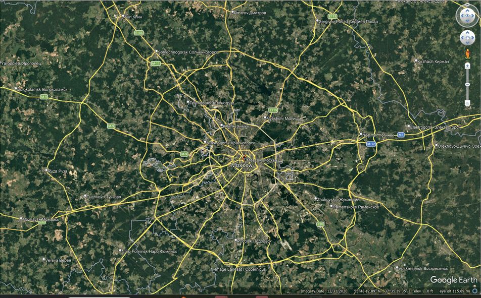
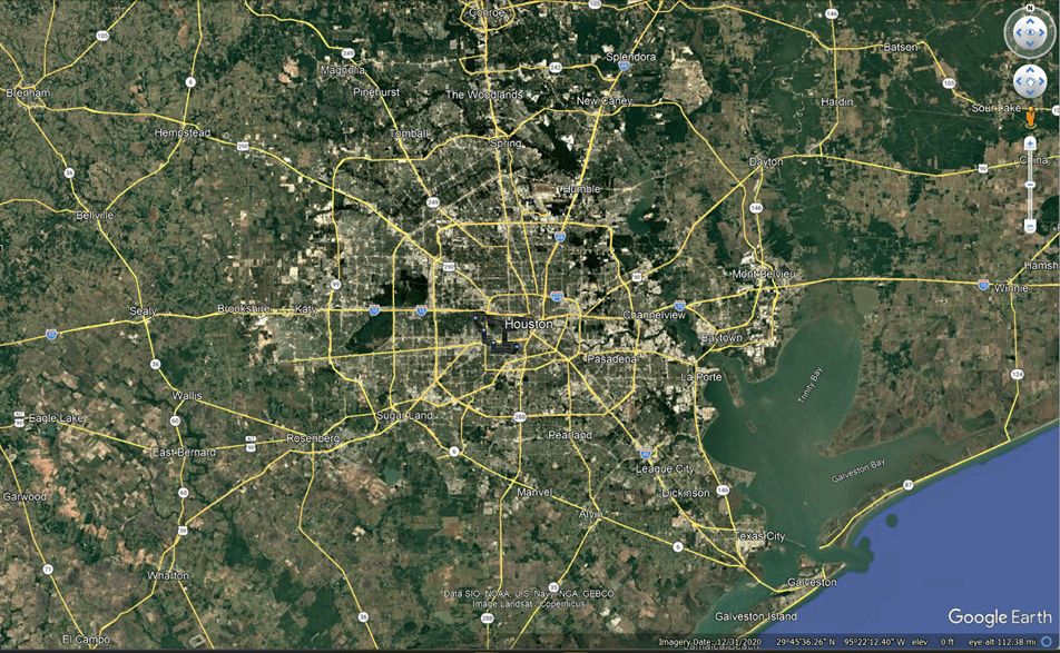
The lighter areas of these GE images show roadways and rooftops.
This is really interesting because Moscow’s urban areas are obviously more compact than Houston’s, and Moscow has retained wooded and open areas. Certainly the Moscow mass transit system allows there to be less roadway space, as fewer people use vehicles and are transported underground. However, Moscow traffic is notorious nonetheless. As we know, this is an example of Braess’ paradox, the observation that adding roads doesn’t really help improve traffic, as it actually slows traffic.
The other major factors in Houston planning are drainage and parking minimums.
As engineers are not mathematicians, we don’t call them parking minima.
More than the absence of zoning in Houston, the parking minimum ordinance determines that character of this city. The area dedicated to parking is determined by the use and the square footage of the structure. Golf clubs, churches, homes, retail businesses, apartment buildings, all have unique required parking minimums.
This means that business without parking can’t exist, and small business located within Houston struggle to meet the ordinance. It means that you can’t really have neighborhoods that allow you to walk to services.
Some neighborhoods are more walkable, like the more affluent Heights and parts of the Montrose. But most of Houston consists of suburban subdivisions of varying ages and lot sizes. Existing within a space like this, a vast and very flat suburban landscape with an amazing uniformity of design and character, always strikes me as odd, and there is a novelty to it, but this is a subject so banal Houstonians and perhaps Texans generally, don’t like to talk about too much. The vastness.
So, parking minima are bad. They’re the real problem here. Some businesses shouldn’t need parking.
The reality of it is that Houston, and Texas, and pretty much the entire country is dedicated to driving around in their cars, and there are no other legitimate alternatives. (In many places, commuting by ebikes and bicycles is rising.)
This dedication is to the detriment of even walking. The older subdivisions generally have no curb and gutter, nor do they have sidewalks. The higher-density newer subdivisions have engineered drainage, but often have no sidewalks. And as these subdivisions only have commercial areas outside of them, and there is no sidewalk connectivity, walking to the convenience store isn’t really safe. Cycling on neighborhoods streets is fine, but the collector streets are usually fast two lane roads, often without shoulders,
It’s a design that forces people to use cars for all transit. Which is fine with most Texans, who can’t live without A/C, although I would note that this is unfair to those many who do work outside in Texas. Let’s respect them for that.
Cycling is very deliberately ignored in Houston. It’s that apparent, and incredibly sad, because Houston has a world class recreational path in the White Oak Bayou Trail, and you have a wealth of other paths and trails, all with no connectivity.
For instance, you can ride on the Buffalo Bayou Trail, but there is no safe way to ride directly to Memorial park, just about one mile west. Instead you have to jump northward to Blossom Street to an oddly placed but very beautiful entrance gate to Memorial Park, a beautiful City Beautiful type stone terraced gate and gardens. If you ride through this Blossom Street gate on a bike, you will encounter a very smooth gravel path, and if you ride along this path admiring how wide and smooth and flat and pleasant a place ride a bicycle it is, you may just be shouted at, because this path is closed to bicycles, which must use the road in this area.
And it should be noted that the White Oak Bayou trail now has two detours, one which will remain for years, part of the I-10 expansion, a project which is also displacing businesses in the East End neighborhood, including a comedy club. Wait, the East End project is the I-45 expansion. Well, you get the idea.
And then, again, there’s drainage. The hydrology of Houston is somewhat like drizzling warm maple syrup onto a pancake. It just pools up.
If you’re not aware, Houston, on average, has severe flood events every seven years. The last bad one was from Hurricane Harvey in 2017. And since then, the question is if the infrastructure improvements have made a dent in the increased flood risk from development.
Back to parking minimums. To go into a little more detail, Houston as made some changes, with no parking minimums in the CBD, and in two neighborhoods, midtown and downtown east in 2019. I will look into what changes have occurred as a result of this policy change.
Some of the parking minimums are odd like, “swimming club, 9.0 parking spaces per employee.
Or, that “bar, club or lounge”, “tavern or pub”, “restaurant’, “neighborhood restaurant”, and “small restaurant” all have different requirements.
The general rule for large businesses is 4.0 parking spaces for every 1,000 square feet of GFA.
This means that the big box stores have lots of parking. The local Walmart is about 400 feet by 500 feet. This implies about 200 parking spaces, but looks to have more than twice this.
The problem is impermeability.
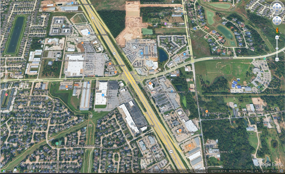
This is a stretch of 249 in Tomball, Texas, with that Walmart just left of center. This commercial area has been annexed by the City of Houston. This area contains a very high fraction of impermeable surface. But the Walmart site doesn’t appear to have retention/detention ponds, which is curious. One can also see in this GE image how the residential neighborhoods are effectively cut off from adjacent commercial areas, with no pedestrian access.
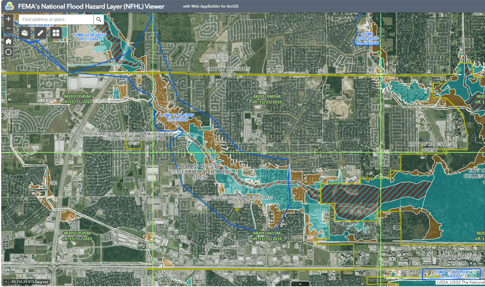
Let’s look at the FEMA flood map of the area:
FEMA’s National Flood Hazard Layer (NFHL) Viewer
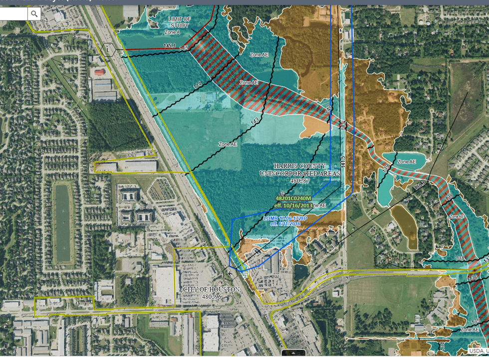
Now Walmart is left of the bottom. The area east of 249 is a flood area, and it’s speculation that runoff from the Walmart site is discharged under the highway to this area. That’s a tributary of Cypress Creek that runs NW-SE through the upper right called Pillot Gully.
This is just a small example of the issues that Houston faces.
As Addicks and Barker Reservoir were mentioned, let’s take a look at the flood map, as the area was just studied and the maps revised.
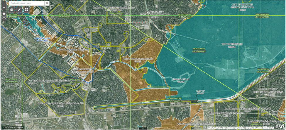
That’s Addicks Reservoir on the right, and the orange areas are zone X, outside of the 500-year flood zone, but let’s look upstream:
In this area we see some blue areas occupied by residential areas. This is not good. As a consequence some owners have taken it upon themselves to raise their homes, and some developers have gone towards placing fill so that the homes themselves are above the flood elevation.
But because these flood studies look primarily at flow along streams, they don’t look at larger more systemic events, and they also lose value at smaller scales. But the line has to be drawn somewhere.

Please leave a comment. I will respond.